
Mapa topográfico Stadtbezirk 22 Aubing-Lochhausen-Langwied
Mapa interativo
Clique no mapa para exibir a altitude.
Sobre este mapa
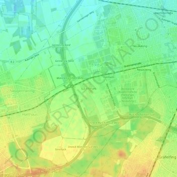
Nome: Mapa topográfico Stadtbezirk 22 Aubing-Lochhausen-Langwied, altitude, relevo.
Altitude média: 537 m
Altitude mínima: 520 m
Altitude máxima: 554 m
Outros mapas topográficos
Clique em um mapa para visualizar sua topografia, sua altitude e seu relevo.
Bezirksteil Altaubing
Deutschland > Bayern > München > Freiham
Bezirksteil Altaubing, Stadtbezirk 22 Aubing-Lochhausen-Langwied, Freiham, München, Oberbayern, Bayern, Deutschland
Altitude média: 521 m