Mapa topográfico Freising
Mapa interativo
Clique no mapa para exibir a altitude.
Sobre este mapa
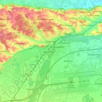
Nome: Mapa topográfico Freising, altitude, relevo.
Local: Freising, Landkreis Freising, Bavaria, Germany (48.33061 11.64045 48.44903 11.79251)
Altitude média: 457 m
Altitude mínima: 419 m
Altitude máxima: 522 m
In 1802/1803 Bavaria fell under the influence of Napoleonic France in which church controlled lands were secularized. In Freising, the more than thousand-year-old bishopric was abolished. The Roman Catholic Church lost most of its properties and authority over the city. Though the seat of the diocese was moved to Munich in 1821, including the elevation to an archdiocese, Freising has remained the seat of diocesan administration until today.
Outros mapas topográficos
Clique em um mapa para visualizar sua topografia, sua altitude e seu relevo.
Neufahrn bei Freising
Germany > Bavaria > Landkreis Freising
Neufahrn bei Freising, Landkreis Freising, Bavaria, Germany
Altitude média: 464 m
85413
Germany > Bavaria > Landkreis Freising > Margarethenried > Sixt in der Point
85413, Sixt in der Point, Margarethenried, Hörgertshausen, Mauern (VGem), Landkreis Freising, Bavaria, Germany
Altitude média: 484 m
Dietersheim
Germany > Bavaria > Landkreis Freising
Dietersheim, Eching, Landkreis Freising, Bavaria, 85386, Germany
Altitude média: 471 m
Günzenhausen
Germany > Bavaria > Landkreis Freising
Günzenhausen, Eching, Landkreis Freising, Bavaria, 85376, Germany
Altitude média: 477 m
Mariabrunn
Germany > Bavaria > Landkreis Freising > Birkeneck
Mariabrunn, Birkeneck, Hallbergmoos, Landkreis Freising, Bavaria, 85399, Germany
Altitude média: 453 m
Spörerau
Germany > Bavaria > Landkreis Freising > Wang
Spörerau, Wang, Mauern (VGem), Landkreis Freising, Bavaria, 84079, Germany
Altitude média: 410 m
Moosburg
Germany > Bavaria > Landkreis Freising
Moosburg, Landkreis Freising, Bavaria, 85368, Germany
Altitude média: 428 m