
Faça uma doação
Mapa topográfico Diamond Ridge
Clique no mapa para exibir a altitude.
Faça uma doação
Diamond Ridge
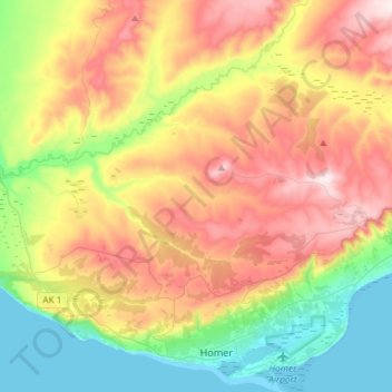
The community is named for the high ground, Diamond Ridge, on which it sits. The ridge reaches an elevation of 1,202 feet (366 m) above sea level and is in the southern part of the CDP. Parallel landforms to the north are Crossman Ridge in the center of the CDP and a ridge connecting 1,513-foot (461 m) Ohlson Mountain and 1,622-foot (494 m) Lookout Mountain in the north. The terrain slopes north from the ridges to the Anchor River, which forms the northern boundary of the CDP.
Faça uma doação
Sobre este mapa
Nome: Mapa topográfico Diamond Ridge, altitude, relevo.
Local: Diamond Ridge, Kenai Peninsula, Alaska, United States (59.65347 -151.70604 59.75272 -151.41287)
Altitude média: 213 m
Altitude mínima: 0 m
Altitude máxima: 494 m
Faça uma doação
Outros mapas topográficos
Clique em um mapa para visualizar sua topografia, sua altitude e seu relevo.
Homer
United States > Alaska > Kenai Peninsula > Homer
Some birds seen during the spring migration and the festival include horned puffins, sandhill cranes, and arctic terns. Arctic Terns are famous for flying the longest distance of any migrating bird. Many of the birds seen during the festival can be identified with the help of published guides that categorize…
Altitude média: 106 m
Faça uma doação
Faça uma doação
Faça uma doação