
Obrigado por apoiar este site ❤️
Faça uma doação
Faça uma doação
Mapa topográfico Washington Terrace
Clique no mapa para exibir a altitude.
Obrigado por apoiar este site ❤️
Faça uma doação
Faça uma doação
Sobre este mapa
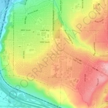
Nome: Mapa topográfico Washington Terrace, altitude, relevo.
Local: Washington Terrace, Weber County, Utah, United States (41.15213 -111.99255 41.18534 -111.96103)
Altitude média: 1.411 m
Altitude mínima: 1.326 m
Altitude máxima: 1.482 m
Obrigado por apoiar este site ❤️
Faça uma doação
Faça uma doação
Outros mapas topográficos
Clique em um mapa para visualizar sua topografia, sua altitude e seu relevo.
Ogden
United States > Utah > Weber County > Ogden
According to the United States Census Bureau, the city has an area of 26.6 square miles (69.0 km2), all land. Elevations in the city range from about 4,300 to 5,000 feet (1,300 to 1,500 m) above sea level.
Altitude média: 1.557 m