
Mapa topográfico Beaverton
Mapa interativo
Clique no mapa para exibir a altitude.
Sobre este mapa
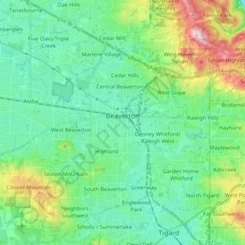
Nome: Mapa topográfico Beaverton, altitude, relevo.
Local: Beaverton, Washington County, Oregon, United States (45.42459 -122.87772 45.54296 -122.74366)
Altitude média: 106 m
Altitude mínima: 15 m
Altitude máxima: 386 m
As of January 2020, Beaverton covers a total area of 19.7 square miles (51 km2), all of it land except for small creeks, ponds, and lakes. The city is located along the eastern edge of the Tualatin Valley just west of the Tualatin Mountains. It is bordered by Portland to the east, Hillsboro to the west, and Tigard to the south. Much of the remaining area surrounding Beaverton in the north and southwest constitutes unincorporated Washington County land. The elevation within city limits ranges from as high as 698.2 feet (212.8 m) above sea level to as low as 131.7 feet (40.1 m) above sea level. The city averages at 189 feet (58 m) above sea level.
Outros mapas topográficos
Clique em um mapa para visualizar sua topografia, sua altitude e seu relevo.
South Beaverton
United States > Oregon > Washington County > Beaverton
South Beaverton, Beaverton, Washington County, Oregon, United States
Altitude média: 79 m
Tigard
United States > Oregon > Washington County
Tigard, Washington County, Oregon, United States
Altitude média: 83 m