
Obrigado por apoiar este site ❤️
Faça uma doação
Faça uma doação
Mapa topográfico Dugway
Clique no mapa para exibir a altitude.
Obrigado por apoiar este site ❤️
Faça uma doação
Faça uma doação
Sobre este mapa
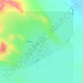
Nome: Mapa topográfico Dugway, altitude, relevo.
Local: Dugway, Tooele County, Utah, 84022, United States (40.21291 -112.78080 40.24445 -112.72336)
Altitude média: 1.496 m
Altitude mínima: 1.452 m
Altitude máxima: 1.618 m
Obrigado por apoiar este site ❤️
Faça uma doação
Faça uma doação
Outros mapas topográficos
Clique em um mapa para visualizar sua topografia, sua altitude e seu relevo.
Ibapah
United States > Utah > Tooele County
The climate is typical of that of a high elevation Great Basin location, being semi-arid and featuring, in consequence, large differences in temperature between day and night.
Altitude média: 1.623 m