
Mapa topográfico St Paul's Walden
Mapa interativo
Clique no mapa para exibir a altitude.
Sobre este mapa
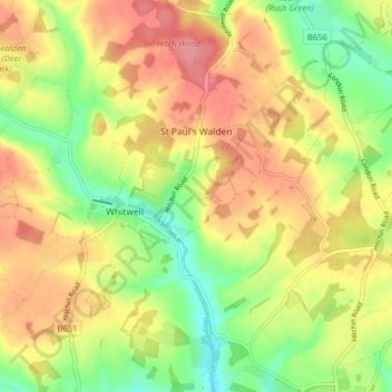
Nome: Mapa topográfico St Paul's Walden, altitude, relevo.
Altitude média: 121 m
Altitude mínima: 79 m
Altitude máxima: 158 m
Outros mapas topográficos
Clique em um mapa para visualizar sua topografia, sua altitude e seu relevo.
Hitchin
United Kingdom > England > Hertfordshire > North Hertfordshire
Hitchin, North Hertfordshire, Hertfordshire, England, SG5 1BB, United Kingdom
Altitude média: 91 m
Barley
United Kingdom > England > Hertfordshire > North Hertfordshire
Barley, North Hertfordshire, Hertfordshire, England, United Kingdom
Altitude média: 103 m
Therfield
United Kingdom > England > Hertfordshire > North Hertfordshire
Therfield, North Hertfordshire, Hertfordshire, England, United Kingdom
Altitude média: 122 m