
Mapa topográfico Copperalley ED
Mapa interativo
Clique no mapa para exibir a altitude.
Sobre este mapa
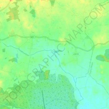
Nome: Mapa topográfico Copperalley ED, altitude, relevo.
Altitude média: 78 m
Altitude mínima: 66 m
Altitude máxima: 96 m
Outros mapas topográficos
Clique em um mapa para visualizar sua topografia, sua altitude e seu relevo.
Middleton ED
Middleton ED, The Municipal District of Athlone — Moate, County Westmeath, Condado de Westmeath, Leinster, N91 W97W, Irlanda
Altitude média: 89 m
Mullingar
Irlanda > County Westmeath > Mullingar
Mullingar, The Municipal District of Mullingar — Kinnegad, County Westmeath, Leinster, N91 FY58, Irlanda
Altitude média: 101 m