
Mapa topográfico Signal Hill
Mapa interativo
Clique no mapa para exibir a altitude.
Signal Hill
Signal Hill (Maori: Te Pahuri o te Rangipohika) is a prominent landform in the city of Dunedin, New Zealand. It is located close to, and due north of, the head of the Otago Harbour and reaches an elevation of 393 m (1289 ft). The suburbs Ravensbourne, St. Leonards, and Opoho lie on its southern, eastern, and northwestern flanks, respectively. To the northwest is North East Valley, the thalweg of Lindsay Creek, a tributary of the Water of Leith. The southernmost spur of Signal Hill, Logan Point, has been extensively quarried for road gravel. State Highway 88 skirts the foot of the hill close to the edge of the Otago Harbour.
Sobre este mapa
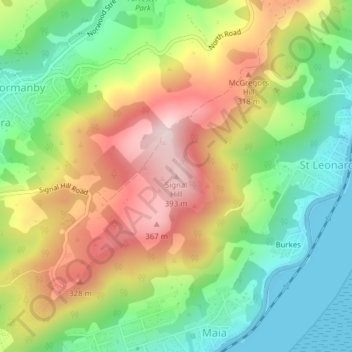
Nome: Mapa topográfico Signal Hill, altitude, relevo.
Altitude média: 174 m
Altitude mínima: 0 m
Altitude máxima: 398 m
Outros mapas topográficos
Clique em um mapa para visualizar sua topografia, sua altitude e seu relevo.