
Mapa topográfico Martinlamitz
Mapa interativo
Clique no mapa para exibir a altitude.
Sobre este mapa
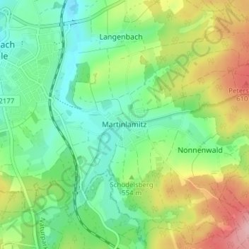
Nome: Mapa topográfico Martinlamitz, altitude, relevo.
Altitude média: 550 m
Altitude mínima: 499 m
Altitude máxima: 642 m
Outros mapas topográficos
Clique em um mapa para visualizar sua topografia, sua altitude e seu relevo.
Stobersreuth
Deutschland > Bayern > Landkreis Hof > Schwarzenbach a.d.Saale
Stobersreuth, Schwarzenbach a.d.Saale, Landkreis Hof, Bayern, 95126, Deutschland
Altitude média: 530 m
Schwingen
Deutschland > Bayern > Landkreis Hof > Schwarzenbach a.d.Saale
Schwingen, Schwarzenbach a.d.Saale, Landkreis Hof, Bayern, 95126, Deutschland
Altitude média: 523 m
Förbau
Deutschland > Bayern > Landkreis Hof > Schwarzenbach a.d.Saale
Förbau, Schwarzenbach a.d.Saale, Landkreis Hof, Bayern, 95126, Deutschland
Altitude média: 532 m
Förmitztalsperre
Deutschland > Bayern > Landkreis Hof > Schwarzenbach a.d.Saale > Völkenreuth
Förmitztalsperre, Völkenreuth, Schwarzenbach a.d.Saale, Landkreis Hof, Bayern, Deutschland
Altitude média: 542 m