
Mapa topográfico Carlsgrün
Mapa interativo
Clique no mapa para exibir a altitude.
Sobre este mapa
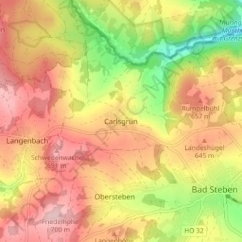
Nome: Mapa topográfico Carlsgrün, altitude, relevo.
Altitude média: 612 m
Altitude mínima: 490 m
Altitude máxima: 703 m
Outros mapas topográficos
Clique em um mapa para visualizar sua topografia, sua altitude e seu relevo.
Lochau
Deutschland > Bayern > Landkreis Hof > Bad Steben
Lochau, Bad Steben, Landkreis Hof, Bayern, 95138, Deutschland
Altitude média: 613 m
Thierbach
Deutschland > Bayern > Landkreis Hof > Bad Steben > Thierbach
Thierbach, Bad Steben, Landkreis Hof, Bayern, 95138, Deutschland
Altitude média: 569 m