
Faça uma doação
Mapa topográfico Markham
Clique no mapa para exibir a altitude.
Faça uma doação
Markham
Markham's average altitude is at 200 m (660 ft) and in general consists of gently rolling hills. The city is intersected by two rivers; the Don River and Rouge River, as well as their tributaries. To the north is the Oak Ridges Moraine, which further elevates the elevation towards the north.
Faça uma doação
Sobre este mapa
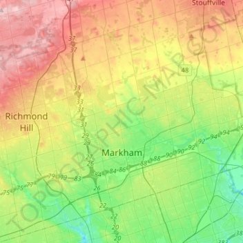
Nome: Mapa topográfico Markham, altitude, relevo.
Local: Markham, York Region, Golden Horseshoe, Ontario, Canada (43.79804 -79.42873 43.96251 -79.17021)
Altitude média: 216 m
Altitude mínima: 135 m
Altitude máxima: 333 m
Faça uma doação
Outros mapas topográficos
Clique em um mapa para visualizar sua topografia, sua altitude e seu relevo.
Faça uma doação
Faça uma doação
Keswick
Canada > Ontario > York Region
Keswick's geographical coordinates are 44.22°N, 79.45°W, and its elevation above sea level is 221m/762 ft. It has a geographical area of 16.25 km² according to Statistics Canada. It is bound on the north by Roches Point, the east by Woodbine Avenue, the south by East Gwillimbury (Ravenshoe Road) and the…
Altitude média: 228 m
Faça uma doação
Faça uma doação
Faça uma doação
Faça uma doação
Faça uma doação
Whitchurch-Stouffville Community Park, Vandorf
Canada > Ontario > York Region > Whitchurch-Stouffville
Altitude média: 305 m
Faça uma doação
Faça uma doação
East Holland River
Canada > Ontario > York Region > East Gwillimbury > Holland Landing
Altitude média: 223 m
Faça uma doação
Faça uma doação
Keswick
Canada > Ontario > York Region
Keswick's geographical coordinates are 44.22°N, 79.45°W, and its elevation above sea level is 221m/762 ft. It has a geographical area of 16.25 km² according to Statistics Canada. It is bound on the north by Roches Point, the east by Woodbine Avenue, the south by East Gwillimbury (Ravenshoe Road) and the…
Altitude média: 228 m
Faça uma doação