
Faça uma doação
Mapa topográfico Rawalpindi
Clique no mapa para exibir a altitude.
Faça uma doação
Rawalpindi
Rawalpindi features a humid subtropical climate (Köppen: Cwa) with hot and wet summers, a cooler and drier winter. Rawalpindi and its twin city Islamabad, during the year experiences an average of 91 thunderstorms, which is the highest frequency of any plain elevation city in the country. Strong windstorms are frequent in the summer during which wind gusts have been reported by Pakistan Meteorological Department to have reached 176 km/h (109 mph). In such thunder/wind storms, which results in some damage of infrastructure. The weather is highly variable due to the proximity of the city to the foothills of Himalayas.
Faça uma doação
Sobre este mapa
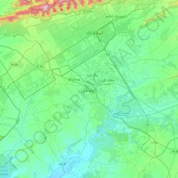
Nome: Mapa topográfico Rawalpindi, altitude, relevo.
Altitude média: 530 m
Altitude mínima: 387 m
Altitude máxima: 1.187 m
Faça uma doação
Outros mapas topográficos
Clique em um mapa para visualizar sua topografia, sua altitude e seu relevo.