
Faça uma doação
Mapa topográfico Pavilion
Clique no mapa para exibir a altitude.
Faça uma doação
Pavilion
The early anglicized version of the village name was Skwailuk, meaning hoar-frost, perhaps indicating the shaded ground remaining frozen during the long winters at this elevation. The Ts'kw'aylaxw First Nation (a.k.a. the Tsk'waylacw First Nation or Tsk'weylecw First Nation), residing on the Pavilion 1 Indian Reserve comprise most of the area population. The Pavilion dialect is a mix of St'at'imcets and Secwepemc'tsn and many of the place names in the surrounding country are Secwepemc'tsn.
Faça uma doação
Sobre este mapa
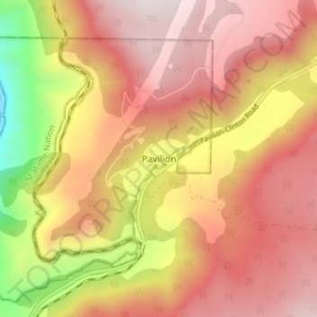
Nome: Mapa topográfico Pavilion, altitude, relevo.
Local: Pavilion, British Columbia, Canada (50.86295 -121.84815 50.90295 -121.80815)
Altitude média: 855 m
Altitude mínima: 240 m
Altitude máxima: 1.241 m
Faça uma doação
Outros mapas topográficos
Clique em um mapa para visualizar sua topografia, sua altitude e seu relevo.
Vancouver
Canada > British Columbia > Metro Vancouver Regional District
Vancouver, British Columbia, is situated on the Burrard Peninsula, bordered by Burrard Inlet to the north and the Fraser River to the south. The city's topography is a blend of flat and hilly terrains, with elevations ranging from sea level to approximately 152 meters (500 feet) above sea level. The North…
Altitude média: 34 m
Victoria
Canada > British Columbia > Capital Regional District
Victoria, British Columbia, is situated on the southern tip of Vancouver Island, Canada, and boasts a diverse and varied topography. The city is characterized by rolling hills, rugged coastal cliffs, and lush valleys, providing a striking contrast between mountainous terrain and flatland areas. To the north…
Altitude média: 17 m
Vancouver Island
The rain shadow effect of the island's mountains, as well as the mountains of Washington's Olympic Peninsula, creates wide variation in precipitation. The west coast is considerably wetter than the east coast. Average annual precipitation ranges from 6,650 mm (262 in) at Hucuktlis Lake on the west coast…
Altitude média: 411 m
Faça uma doação
Coquitlam
Canada > British Columbia > Metro Vancouver Regional District
Like much of Metro Vancouver, Coquitlam has an oceanic climate (Köppen climate type Cfb), experiencing mild temperatures and high precipitation; warm, dry summers and cool, wet winters. However, compared to most other cities in the area, precipitation is especially heavy in Coquitlam due to its proximity to…
Altitude média: 190 m
Kelowna
Canada > British Columbia > Regional District of Central Okanagan
Kelowna is classified as a humid continental climate or an inland oceanic climate per the Köppen climate classification system due to its coldest month having an average temperature slightly above −3.0 °C (26.6 °F) and below 0 °C (32 °F), with dry, hot, sunny summers and cool, cloudy winters, and four…
Altitude média: 704 m
Faça uma doação
Burnaby
Canada > British Columbia > Metro Vancouver Regional District
Burnaby occupies 98.6 square kilometres (38.1 sq mi) and is located at the geographic centre of the Metro Vancouver Regional District. The regional district's government is located in Burnaby's Metrotown area. Situated between the city of Vancouver on the west and Port Moody, Coquitlam, and New Westminster on…
Altitude média: 59 m
Faça uma doação
Gabriola Island
Canada > British Columbia > Regional District of Nanaimo > Area B (DeCourcy/Gabriola/Mudge)
Gabriola is about 14 kilometres (9 mi) long by 4.2 kilometres (2.6 mi) wide on average with a land area of 57.6 square kilometres (22.2 sq mi). The topography varies from flat sandy beaches at sea level to forested hills rising to 160 metres (525 ft) on Stoney Ridge in the centre of the island.
Altitude média: 26 m
Vancouver Island
The rain shadow effect of the island's mountains, as well as the mountains of Washington's Olympic Peninsula, creates wide variation in precipitation. The west coast is considerably wetter than the east coast. Average annual precipitation ranges from 6,650 mm (262 in) at Hucuktlis Lake on the west coast…
Altitude média: 411 m
Faça uma doação
Faça uma doação
North Pender Island
Canada > British Columbia > Capital Regional District > Southern Gulf Islands Electoral Area
Altitude média: 23 m
Lundbom Lake
Canada > British Columbia > Thompson-Nicola Regional District > Area N (Beautiful Nicola Valley - South)
Altitude média: 1.158 m
Faça uma doação
Gambier Island
Canada > British Columbia > Sunshine Coast Regional District > Area F (West Howe Sound)
Altitude média: 130 m
Mara Lake
Canada > British Columbia > Columbia-Shuswap Regional District > Area E (Eagle River Valley) > Swansea Point
The lake is 35.3 kilometres (21.9 mi) long. The surface area is about 1,943 hectares (4,800 acres) and elevation is 338 metres (1,109 ft) above sea level. The mean and maximum depth is 18 metres (59 ft).
Altitude média: 826 m
South Thompson River
Canada > British Columbia > Thompson-Nicola Regional District > Kamloops
Altitude média: 421 m
Summerland
Canada > British Columbia > Regional District of Okanagan-Similkameen
Altitude média: 696 m
Faça uma doação
University Endowment Lands
Canada > British Columbia > Metro Vancouver Regional District
Snowfalls are also more common than many parts of the City of Vancouver because of the area's higher altitude and the lack of an urban heat island due to less terrestrial development.
Altitude média: 58 m
Malcolm Island
Canada > British Columbia > Regional District of Mount Waddington > Area A (Seymour Inlet/Knight Inlet)
Altitude média: 21 m
Faça uma doação
Faça uma doação
Faça uma doação
Prince George
Canada > British Columbia > Regional District of Fraser-Fort George
The area has a humid continental climate (Köppen climate classification Dfb, Trewartha Dclo), but is close to (and once had) a subarctic climate (Dfc) as May and September averages are both close to the 10 °C (50 °F) threshold. Winters are milder than the latitude and elevation might suggest: the January…
Altitude média: 685 m
Faça uma doação
Prince Rupert
Canada > British Columbia > North Coast Regional District
Prince Rupert Airport (YPR/CYPR) is on Digby Island. Its position is 54°17′10″N 130°26′41″W / 54.28611°N 130.44472°W / 54.28611; -130.44472, and its elevation is 35 m (116 ft) above sea level. The airport consists of one runway, one passenger terminal, and two aircraft stands. Access to…
Altitude média: 91 m
Mission
Canada > British Columbia > Fraser Valley Regional District
The western part of the district, the Stave Valley, is largely rural and forested but its watercourse is home to what was the largest hydroelectric project in British Columbia until the Bridge River Power Project opened in 1961. It was built by the British Columbia Electric Railway (BCER) to provide power to…
Altitude média: 345 m
Faça uma doação
Faça uma doação
Township of Langley
Canada > British Columbia > Metro Vancouver Regional District
Altitude média: 47 m
Faça uma doação
Saltspring Island
Canada > British Columbia > Capital Regional District > Salt Spring Island Electoral Area
Altitude média: 72 m
Cortes Island
Canada > British Columbia > Strathcona Regional District > Area B (Cortes Island)
Altitude média: 72 m
Faça uma doação
Faça uma doação
Faça uma doação
Savary Island
Canada > British Columbia > qathet Regional District > Area A (Malaspina/Toba)
Altitude média: 3 m
West End
Canada > British Columbia > Metro Vancouver Regional District > Vancouver
Altitude média: 15 m
Gilford Island
Canada > British Columbia > Regional District of Mount Waddington > Area A (Seymour Inlet/Knight Inlet)
Altitude média: 269 m
Faça uma doação
Goldstream River
Canada > British Columbia > Capital Regional District > Juan de Fuca Electoral Area
Altitude média: 247 m
Faça uma doação
Faça uma doação
Revelstoke
Canada > British Columbia > Columbia-Shuswap Regional District
A small ski resort featuring a single short lift has operated on Mount MacKenzie since the 1960s, and snowcat skiing was offered for higher altitudes. A strong movement pushed to expand the entire mountain into a single resort, and construction started in the early 2000s (decade).
Altitude média: 982 m
Faça uma doação
Vancouver
Canada > British Columbia > Metro Vancouver Regional District
Vancouver, British Columbia, is situated on the Burrard Peninsula, bordered by Burrard Inlet to the north and the Fraser River to the south. The city's topography is a blend of flat and hilly terrains, with elevations ranging from sea level to approximately 152 meters (500 feet) above sea level. The North…
Altitude média: 34 m
Faça uma doação
Faça uma doação
Faça uma doação
Faça uma doação