
Faça uma doação
Mapa topográfico Harrisville
Clique no mapa para exibir a altitude.
Faça uma doação
Sobre este mapa
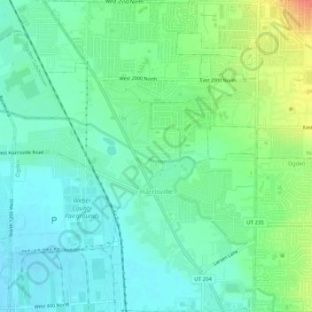
Nome: Mapa topográfico Harrisville, altitude, relevo.
Local: Harrisville, Weber County, Utah, 84404, United States (41.26662 -112.00898 41.30427 -111.96912)
Altitude média: 1.314 m
Altitude mínima: 1.295 m
Altitude máxima: 1.358 m
Faça uma doação
Outros mapas topográficos
Clique em um mapa para visualizar sua topografia, sua altitude e seu relevo.
Eden
United States > Utah > Weber County > Ogden Valley
Eden is a census-designated place in Weber County, Utah, United States. It is home to Powder Mountain ski resort. It lies between the North and Middle Fork of the Ogden River, north of Pineview Reservoir, in the Ogden Valley. The elevation is 4,941 feet (1,506 m). The population was 600 at the 2010 census. It…
Altitude média: 1.562 m
Eden
United States > Utah > Weber County
Eden is a census-designated place in Weber County, Utah, United States. It is home to Powder Mountain ski resort. It lies between the North and Middle Fork of the Ogden River, north of Pineview Reservoir, in the Ogden Valley. The elevation is 4,941 feet (1,506 m). The population was 600 at the 2010 census. It…
Altitude média: 1.562 m
Faça uma doação
Faça uma doação
Ogden
United States > Utah > Weber County > Ogden
According to the United States Census Bureau, the city has an area of 26.6 square miles (69.0 km2), all land. Elevations in the city range from about 4,300 to 5,000 feet (1,300 to 1,500 m) above sea level.
Altitude média: 1.557 m