
Mapa topográfico Besançon
Mapa interativo
Clique no mapa para exibir a altitude.
Besançon
The city initially developed in a natural meander (or oxbow loop) of the river Doubs with a diameter of almost 1,000 metres (3,281 feet). The flat inner loop has an elevation of about 250 metres (820 feet), and is bounded to the south by a hill called Mont Saint-Étienne, which has a maximum height of 371 metres (1,217 feet). The city is surrounded by six other hills which range in elevation from 400 to 500 metres (1,312 to 1,640 feet): Brégille, Griffon, Planoise, Chaudanne, Montfaucon, and Montboucon. (There is a barge canal that cuts through rock under Mont Saint-Étienne, short-cutting the meander.)
Sobre este mapa
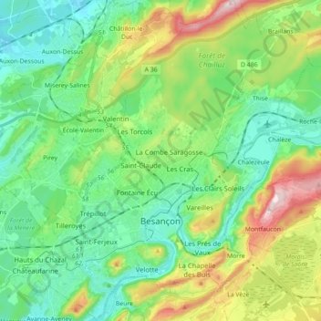
Nome: Mapa topográfico Besançon, altitude, relevo.
Altitude média: 332 m
Altitude mínima: 217 m
Altitude máxima: 608 m