
Mapa topográfico Frederick
Clique no mapa para exibir a altitude.
Sobre este mapa
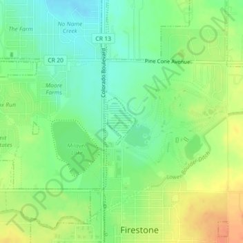
Nome: Mapa topográfico Frederick, altitude, relevo.
Local: Frederick, Weld County, Colorado, United States (40.12189 -104.94131 40.12722 -104.93725)
Altitude média: 1.511 m
Altitude mínima: 1.492 m
Altitude máxima: 1.534 m
Outros mapas topográficos
Clique em um mapa para visualizar sua topografia, sua altitude e seu relevo.
Pawnee National Grassland
United States > Colorado > Weld County
The grassland is a part of the short grass plains of North America. The best example of this ecosystem are preserved around the Pawnee Buttes where grazing and intensive agriculture have had less impact. There are eleven vegetation zones represented with the most unique being the scarp woodlands on the north…
Altitude média: 1.510 m
Greeley
United States > Colorado > Weld County > Greeley > Greeley
Greeley experiences a semi-arid climate (Köppen BSk). High temperatures are generally around 90–95 °F (32 °C) in the summer and 40-45 °F (4 °C) in the winter, although significant variation occurs. The hottest days generally occur around the third week of July and the coldest in January. Nighttime lows…
Altitude média: 1.458 m