

Mapa topográfico Long Beach
Clique no mapa para exibir a altitude.
Long Beach
Willow Springs Park was founded as a part of the Willow Springs Wetlands Restoration Project which opened in October 2017. The project restored 11 acres of a 48-acre degraded oil well site into wetlands. These highlight the pivotal role the ecosystem played in the City of Long Beach's establishment in the late 1800's and helps preserve the site's history and unique topography. It is now at about 16 acres restored and, in August 2024, it began the process of being dedicated as a open space by the city council, which will make it the largest green space in Central Long Beach once done. It is run in collaboration with the city's office of Climate Action and Sustainability which was established in 2008 to support and advance environmental stewardship and equity in the City of Long Beach.
Sobre este mapa
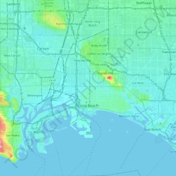
Nome: Mapa topográfico Long Beach, altitude, relevo.
Local: Long Beach, Los Angeles County, California, United States (33.69058 -118.24897 33.88556 -118.06324)
Altitude média: 12 m
Altitude mínima: -5 m
Altitude máxima: 129 m
Outros mapas topográficos
Clique em um mapa para visualizar sua topografia, sua altitude e seu relevo.

Point Dume
United States > California > Los Angeles County > Malibu
Offshore, the nutrient-rich and frigid waters of the Pacific enhance the entire marine food web, from primary producers such as algae and zooplankton to apex predators like sand sharks, bottlenose dolphins, and gray whales. Within the Marine Protected Areas (MPAs), the diverse seafloor topography encompasses…
Altitude média: 12 m