
Mapa topográfico Bayerisch Eisenstein
Mapa interativo
Clique no mapa para exibir a altitude.
Sobre este mapa
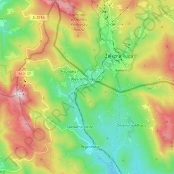
Nome: Mapa topográfico Bayerisch Eisenstein, altitude, relevo.
Altitude média: 919 m
Altitude mínima: 597 m
Altitude máxima: 1.445 m
Outros mapas topográficos
Clique em um mapa para visualizar sua topografia, sua altitude e seu relevo.
Geiersthal
Deutschland > Bayern > Landkreis Regen
Geiersthal, Landkreis Regen, Bayern, Deutschland
Altitude média: 538 m
Altwies
Deutschland > Bayern > Landkreis Regen > Unterviechtafell > Altwies
Altwies, Unterviechtafell, Prackenbach, Landkreis Regen, Bayern, 94267, Deutschland
Altitude média: 536 m