
Mapa topográfico Hinterwössen
Mapa interativo
Clique no mapa para exibir a altitude.
Sobre este mapa
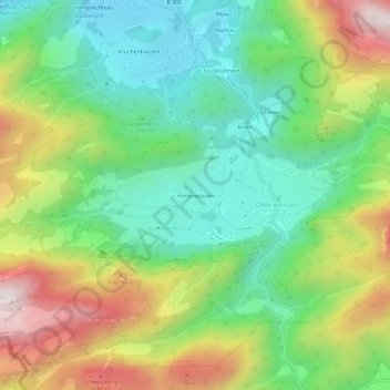
Nome: Mapa topográfico Hinterwössen, altitude, relevo.
Altitude média: 844 m
Altitude mínima: 556 m
Altitude máxima: 1.328 m
Outros mapas topográficos
Clique em um mapa para visualizar sua topografia, sua altitude e seu relevo.
Litzelau
Deutschland > Bayern > Landkreis Traunstein > Oberwössen > Litzelau
Litzelau, Oberwössen, Unterwössen, Landkreis Traunstein, Bayern, 83246, Deutschland
Altitude média: 821 m