
Faça uma doação
Mapa topográfico Reading
Clique no mapa para exibir a altitude.
Faça uma doação
Reading
Jane Austen attended Reading Ladies Boarding School, based in the Abbey Gateway, in 1784–1786. Mary Russell Mitford lived in Reading for a number of years and then spent the rest of her life just outside the town at Three Mile Cross and Swallowfield. The fictional Belford Regis of her eponymous novel, first published in 1835, is largely based on Reading. Described with topographical accuracy, it is still possible to follow the steps of the novel's characters in present-day Reading. Reading also appears in the works of Thomas Hardy where it is called 'Aldbrickham'. It features most heavily in his final novel, Jude the Obscure, as the temporary home of Jude Fawley and Sue Bridehead.
Faça uma doação
Sobre este mapa
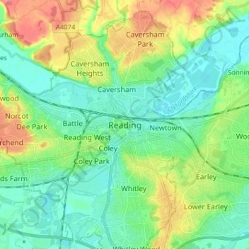
Nome: Mapa topográfico Reading, altitude, relevo.
Local: Reading, England, RG1 1JL, United Kingdom (51.41642 -1.01007 51.49642 -0.93007)
Altitude média: 56 m
Altitude mínima: 32 m
Altitude máxima: 108 m
Faça uma doação
Outros mapas topográficos
Clique em um mapa para visualizar sua topografia, sua altitude e seu relevo.
Berkshire
United Kingdom > England > Reading
All of the county is drained by the Thames. Berkshire divides into two topological (and associated geological) sections: east and west of Reading. North-east Berkshire has the low calciferous (limestone) m-shaped bends of the Thames south of which is a broader, clayey, gravelly former watery plain or belt from…
Altitude média: 100 m
Faça uma doação