
Faça uma doação
Mapa topográfico Craponne-sur-Arzon
Clique no mapa para exibir a altitude.
Faça uma doação
Craponne-sur-Arzon
Located on a granitic plateau mostly situated at more than 900 meters elevation, the commune has a minimum elevation of 771 meters, near the Bois de l'Or along the river Ance in the south-east part of the commune. Its maximum elevation is about 1063 meters, the highest point being located near the place called Le Fêtre, in the north of the town.
Faça uma doação
Sobre este mapa
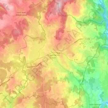
Nome: Mapa topográfico Craponne-sur-Arzon, altitude, relevo.
Altitude média: 929 m
Altitude mínima: 772 m
Altitude máxima: 1.057 m
Faça uma doação
Outros mapas topográficos
Clique em um mapa para visualizar sua topografia, sua altitude e seu relevo.
Faça uma doação
Cheneville
France > Auvergne-Rhône-Alpes > Haute-Loire > Varennes-Saint-Honorat
Altitude média: 1.055 m
Laniac
France > Auvergne-Rhône-Alpes > Haute-Loire > Siaugues-Sainte-Marie > Siaugues-Saint-Romain
Altitude média: 909 m
Faça uma doação
Faça uma doação
Faça uma doação