
Faça uma doação
Mapa topográfico Burr Ridge
Clique no mapa para exibir a altitude.
Faça uma doação
Sobre este mapa
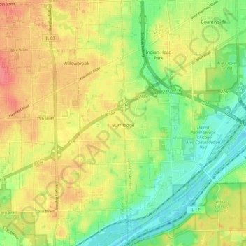
Nome: Mapa topográfico Burr Ridge, altitude, relevo.
Local: Burr Ridge, DuPage County, Illinois, 65027, United States (41.71228 -87.94522 41.78957 -87.89267)
Altitude média: 209 m
Altitude mínima: 177 m
Altitude máxima: 242 m
Faça uma doação
Outros mapas topográficos
Clique em um mapa para visualizar sua topografia, sua altitude e seu relevo.
Elmhurst
United States > Illinois > DuPage County
Due to local topography, the town has had a tendency to flood in the past after large rainfalls; the city is currently undertaking a large effort to mitigate future flooding.
Altitude média: 207 m
Elmhurst
United States > Illinois > DuPage County
Due to local topography, the town has had a tendency to flood in the past after large rainfalls; the city is currently undertaking a large effort to mitigate future flooding.
Altitude média: 207 m
Faça uma doação