
Mapa topográfico Teutoburger Wald
Mapa interativo
Clique no mapa para exibir a altitude.
Sobre este mapa
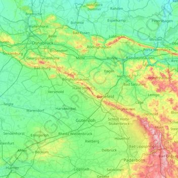
Nome: Mapa topográfico Teutoburger Wald, altitude, relevo.
Altitude média: 105 m
Altitude mínima: 31 m
Altitude máxima: 462 m
Outros mapas topográficos
Clique em um mapa para visualizar sua topografia, sua altitude e seu relevo.
Stukenbrock
Duitsland > Noordrijn-Westfalen > Kreis Gütersloh > Schloß Holte-Stukenbrock
Stukenbrock, Schloß Holte-Stukenbrock, Kreis Gütersloh, Noordrijn-Westfalen, 33758, Duitsland
Altitude média: 135 m
Gütersloh
Duitsland > Noordrijn-Westfalen > Kreis Gütersloh
Gütersloh, Kreis Gütersloh, Noordrijn-Westfalen, Duitsland
Altitude média: 80 m
Halle (Westf.)
Duitsland > Noordrijn-Westfalen > Kreis Gütersloh
Halle (Westf.), Kreis Gütersloh, Noordrijn-Westfalen, 33790, Duitsland
Altitude média: 125 m
Rietberg
Duitsland > Noordrijn-Westfalen > Kreis Gütersloh > Rietberg > Rietberg
Rietberg, Kreis Gütersloh, Noordrijn-Westfalen, 33397, Duitsland
Altitude média: 80 m