
Faça uma doação
Mapa topográfico Ellijay
Clique no mapa para exibir a altitude.
Faça uma doação
Ellijay
Ellijay sits within a rugged and mountainous terrain, characterized by rolling hills, deep valleys, and ridgelines that are part of the larger Appalachian Mountain system. The area has an average elevation of about 1,390 feet, though nearby peaks like Walnut Mountain rise to elevations over 2,500 feet. The landscape is shaped by a series of steep ridges and creeks, with significant features such as the Cartecay and Ellijay Rivers weaving through the valleys. The region's topography provides stunning vistas and is ideal for outdoor activities like hiking and river rafting, with the mountains offering both a natural barrier and a unique ecological environment. This combination of elevation and terrain makes Ellijay a prime destination for nature lovers and adventure seekers.
Faça uma doação
Sobre este mapa
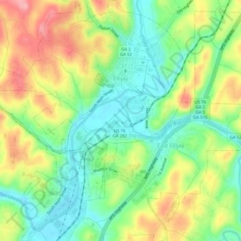
Nome: Mapa topográfico Ellijay, altitude, relevo.
Local: Ellijay, Gilmer County, Georgia, 30540, United States (34.66807 -84.51152 34.70778 -84.46965)
Altitude média: 424 m
Altitude mínima: 373 m
Altitude máxima: 496 m
Faça uma doação
Outros mapas topográficos
Clique em um mapa para visualizar sua topografia, sua altitude e seu relevo.