
Mapa topográfico Spokane
Mapa interativo
Clique no mapa para exibir a altitude.
Sobre este mapa
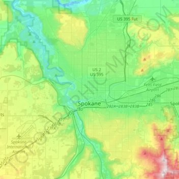
Nome: Mapa topográfico Spokane, altitude, relevo.
Local: Spokane, Spokane County, Washington, United States (47.58678 -117.60400 47.75880 -117.30386)
Altitude média: 655 m
Altitude mínima: 470 m
Altitude máxima: 1.116 m
Spokane is located on the Spokane River in eastern Washington at an elevation of 1,843 feet (562 m) above sea level, about 18 miles (29 km) from Idaho, 92 miles (148 km) south of the Canadian border, 229 miles (369 km) due east of Seattle, and 279 miles (449 km) southwest of Calgary. The lowest elevation in the city of Spokane is the northernmost point of the Spokane River within city limits (in Riverside State Park) at 1,608 feet (490 m); the highest elevation is on the northeast side, near the community of Hillyard (though closer to Beacon Hill and the North Hill Reservoir) at 2,591 feet (790 m). Spokane is part of the Inland Northwest region, consisting of eastern Washington, north Idaho, northwestern Montana, and northeastern Oregon. The city has a total area of 60.02 square miles (155.45 km2), of which 59.25 square miles (153.46 km2) is land and 0.77 square miles (1.99 km2) is water.
Outros mapas topográficos
Clique em um mapa para visualizar sua topografia, sua altitude e seu relevo.
Spokane Valley
United States > Washington > Spokane County
Spokane Valley, Spokane County, Washington, United States
Altitude média: 673 m
Hampton Bay
United States > Washington > Spokane County
Hampton Bay, Spokane County, Washington, United States
Altitude média: 666 m
Nine Mile Falls
United States > Washington > Spokane County
Nine Mile Falls, Spokane County, Washington, 99026, United States
Altitude média: 536 m
Mica Peak
United States > Washington > Spokane County
Mica Peak, Spokane County, Washington, United States
Altitude média: 1.311 m
Otis Orchards-East Farms
United States > Washington > Spokane County
Otis Orchards-East Farms, Spokane County, Washington, United States
Altitude média: 668 m
Mount Spokane State Park
United States > Washington > Spokane County
Mount Spokane State Park, Spokane County, Washington, United States
Altitude média: 976 m
Country Homes
United States > Washington > Spokane County
Country Homes, Spokane County, Washington, 99251, United States
Altitude média: 599 m
Mead
United States > Washington > Spokane County
Mead, Spokane County, Washington, 99021, United States
Altitude média: 585 m
Mica
United States > Washington > Spokane County
Mica, Spokane County, Washington, 99023, United States
Altitude média: 772 m
East Spokane
United States > Washington > Spokane County > Spokane Valley > East Spokane
East Spokane, Spokane Valley, Spokane County, Washington, 99260, United States
Altitude média: 625 m
Riverfront Park
United States > Washington > Spokane County > Spokane
Riverfront Park, Spokane, Spokane County, Washington, United States
Altitude média: 583 m
Beacon Hill
United States > Washington > Spokane County
Beacon Hill, Spokane County, Washington, 99211, United States
Altitude média: 659 m
Orchard Prairie
United States > Washington > Spokane County
Orchard Prairie, Spokane County, Washington, United States
Altitude média: 682 m