
Faça uma doação
Mapa topográfico Crossville
Clique no mapa para exibir a altitude.
Faça uma doação
Crossville
Crossville is located at the center of Cumberland County at 35°57′15″N 85°1′53″W / 35.95417°N 85.03139°W / 35.95417; -85.03139 (35.954221, -85.031267). The city is situated atop the Cumberland Plateau amidst the headwaters of the Obed River, which slices a gorge north of Crossville en route to its confluence with the Emory River to the northeast. Crossville is roughly halfway between the plateau's eastern escarpment along Walden Ridge and its western escarpment along the Highland Rim. Several small lakes are located on the outskirts of Crossville, including Lake Tansi to the south, Lake Holiday to the west, and Byrd Lake at nearby Cumberland Mountain State Park. The average elevation of Crossville is approximately 1,890 feet (580 m) above sea level.
Faça uma doação
Sobre este mapa
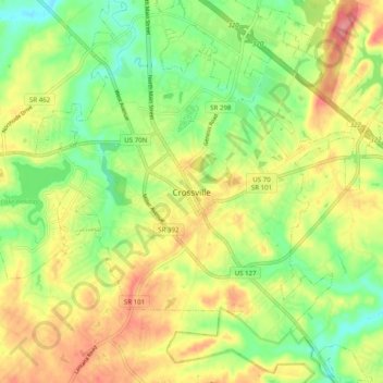
Nome: Mapa topográfico Crossville, altitude, relevo.
Altitude média: 555 m
Altitude mínima: 513 m
Altitude máxima: 602 m
Faça uma doação