
Mapa topográfico Graham County
Mapa interativo
Clique no mapa para exibir a altitude.
Graham County
According to the U.S. Census Bureau, the county has a total area of 302 square miles (780 km2), of which 292 square miles (760 km2) is land and 9.6 square miles (25 km2) (3.2%) is water. The terrain of the county is mountainous, with elevations ranging from 1,177 feet (359 m) to 5,560 feet (1,690 m). Two-thirds of the county is the Nantahala National Forest. The soil of the valleys is fertile.
Sobre este mapa
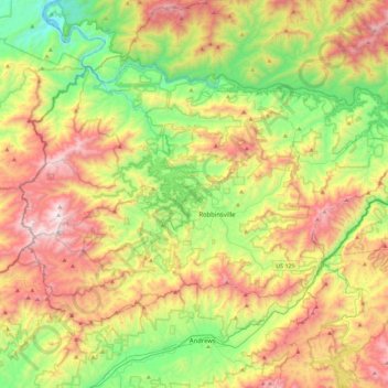
Nome: Mapa topográfico Graham County, altitude, relevo.
Local: Graham County, North Carolina, United States of America (35.21693 -84.03808 35.46652 -83.58240)
Altitude média: 850 m
Altitude mínima: 265 m
Altitude máxima: 1.686 m