
Mapa topográfico Değirmendere
Mapa interativo
Clique no mapa para exibir a altitude.
Sobre este mapa
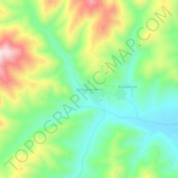
Nome: Mapa topográfico Değirmendere, altitude, relevo.
Local: Değirmendere, Çorum Merkez, Çorum, Black Sea Region, Turkey (40.65736 35.08242 40.69736 35.12242)
Altitude média: 1.263 m
Altitude mínima: 1.103 m
Altitude máxima: 1.535 m
Çorum (Turkish pronunciation: [ˈtʃoɾum]) (Medieval Greek: Ευχάνεια, romanized: Euchaneia) is a northern Anatolian city that is the capital of the Çorum Province of Turkey. Çorum is located inland in the central Black Sea Region of Turkey, and is approximately 244 km (152 mi) from Ankara and 608 km (378 mi) from Istanbul. The city has an elevation of 801 m (2,628 ft) above sea level, a surface area of 12,820 km2 (4,950 sq mi), and as of the 2016 census, a population of 237,000.[3]
Outros mapas topográficos
Clique em um mapa para visualizar sua topografia, sua altitude e seu relevo.
Kavacık
Turkey > Çorum Merkez > Kavacık
Kavacık, Çorum Merkez, Çorum, Black Sea Region, Turkey
Altitude média: 1.113 m
Elmalı
Turkey > Çorum Merkez > Elmalı
Elmalı, Çorum Merkez, Çorum, Black Sea Region, Turkey
Altitude média: 1.125 m