
Mapa topográfico Loreto
Mapa interativo
Clique no mapa para exibir a altitude.
Sobre este mapa
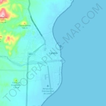
Nome: Mapa topográfico Loreto, altitude, relevo.
Altitude média: 22 m
Altitude mínima: -1 m
Altitude máxima: 313 m
Loreto is located on the east coast of the Baja California Peninsula, at 26º00'46" N 111º20'36" W. It is bordered on the east by the Gulf of California, on the west by the Transpeninsular Highway, and on the south by the Arroyo Loreto, a dry creek bed that only fills with water after a heavy rainfall. The city is built on relatively flat land with an average elevation is 10 meters (33 ft) above sea level. "La Giganta" Mountain Range ("Sierra de la Giganta") lies to the west, extending along the center of the state of Baja California Sur, parallel to the gulf coast.
Outros mapas topográficos
Clique em um mapa para visualizar sua topografia, sua altitude e seu relevo.
Nopoló
Mexico > Baja California Sur > Municipio de Loreto
Nopoló, Municipio de Loreto, Baja California Sur, Mexico
Altitude média: 65 m