
Mapa topográfico Langenthal
Mapa interativo
Clique no mapa para exibir a altitude.
Sobre este mapa
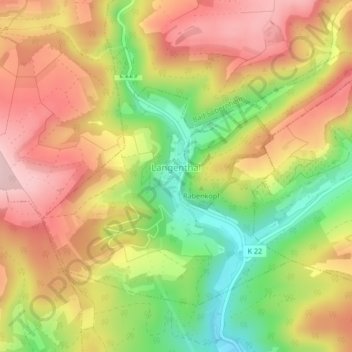
Nome: Mapa topográfico Langenthal, altitude, relevo.
Altitude média: 319 m
Altitude mínima: 190 m
Altitude máxima: 426 m
Outros mapas topográficos
Clique em um mapa para visualizar sua topografia, sua altitude e seu relevo.
Winterbach
Deutschland > Rheinland-Pfalz > Landkreis Bad Kreuznach
Winterbach, Rüdesheim, Landkreis Bad Kreuznach, Rheinland-Pfalz, Deutschland
Altitude média: 467 m
Desloch
Deutschland > Rheinland-Pfalz > Landkreis Bad Kreuznach
Desloch, Nahe-Glan, Landkreis Bad Kreuznach, Rheinland-Pfalz, Deutschland
Altitude média: 300 m
Stromberg
Deutschland > Rheinland-Pfalz > Landkreis Bad Kreuznach
Stromberg, Langenlonsheim-Stromberg, Landkreis Bad Kreuznach, Rheinland-Pfalz, 55442, Deutschland
Altitude média: 325 m
Rüdesheim
Deutschland > Rheinland-Pfalz > Landkreis Bad Kreuznach
Rüdesheim, Landkreis Bad Kreuznach, Rheinland-Pfalz, 55593, Deutschland
Altitude média: 165 m