
Faça uma doação
Mapa topográfico Malolos
Clique no mapa para exibir a altitude.
Faça uma doação
Malolos
Malolos is relatively flat of about 0.81% to a gently sloping of 2.17%. The slope of the land descends towards west, southwest to southern direction. The highest land elevation is at about 6.0 meters above sea level while the lowest is only half a meter below sea level. A network of natural waterways and rivers of various sizes and importance is traversing through the landscape of the town down south to Manila Bay.
Faça uma doação
Sobre este mapa
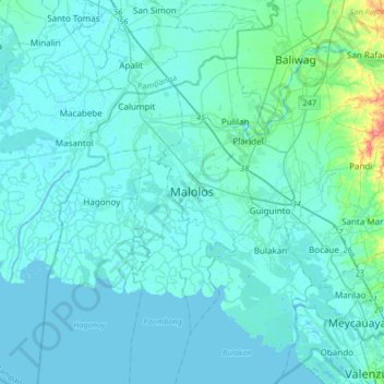
Nome: Mapa topográfico Malolos, altitude, relevo.
Local: Malolos, Bulacan, Central Luzon, 3000, Philippines (14.68376 120.65137 15.00376 120.97137)
Altitude média: 6 m
Altitude mínima: -3 m
Altitude máxima: 74 m
Faça uma doação
Outros mapas topográficos
Clique em um mapa para visualizar sua topografia, sua altitude e seu relevo.
Biak na Bato National Park
Philippines > Bulacan > Doña Remedios Trinidad > Talbak
Altitude média: 127 m
Faça uma doação
Doña Remedios Trinidad
List of highest peaks in D.R.T by elevation.
Altitude média: 172 m