
Mapa topográfico Sankt Goar
Mapa interativo
Clique no mapa para exibir a altitude.
Sobre este mapa
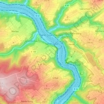
Nome: Mapa topográfico Sankt Goar, altitude, relevo.
Altitude média: 232 m
Altitude mínima: 67 m
Altitude máxima: 423 m
Die Stadt besteht aus der am Rhein liegenden Kernstadt Sankt Goar, den Höhenstadtteilen Biebernheim und Werlau, dem nördlich am Rhein gelegenen Stadtteil Fellen und dem südlich am Rhein gelegenen Stadtteil An der Loreley.
Outros mapas topográficos
Clique em um mapa para visualizar sua topografia, sua altitude e seu relevo.
Fronhofen
Deutschland > Rheinland-Pfalz > Rhein-Hunsrück-Kreis
Fronhofen, Simmern-Rheinböllen, Rhein-Hunsrück-Kreis, Rheinland-Pfalz, Deutschland
Altitude média: 398 m
Simmern/Hunsrück
Deutschland > Rheinland-Pfalz > Rhein-Hunsrück-Kreis
Simmern/Hunsrück, Simmern-Rheinböllen, Rhein-Hunsrück-Kreis, Rheinland-Pfalz, 55469, Deutschland
Altitude média: 379 m
Zilshausen
Deutschland > Rheinland-Pfalz > Rhein-Hunsrück-Kreis
Zilshausen, Kastellaun, Rhein-Hunsrück-Kreis, Rheinland-Pfalz, Deutschland
Altitude média: 327 m
Hahn
Deutschland > Rheinland-Pfalz > Rhein-Hunsrück-Kreis > Hahn
Hahn, Kirchberg (Hunsrück), Rhein-Hunsrück-Kreis, Rheinland-Pfalz, Deutschland
Altitude média: 462 m
Boppard
Deutschland > Rheinland-Pfalz > Rhein-Hunsrück-Kreis > Boppard
Boppard, Rhein-Hunsrück-Kreis, Rheinland-Pfalz, 56154, Deutschland
Altitude média: 307 m