
Faça uma doação
Mapa topográfico Kingman
Clique no mapa para exibir a altitude.
Faça uma doação
Kingman
Lt. Edward Fitzgerald Beale, a U.S. Navy officer in the service of the Army Corps of Topographical Engineers, was ordered by the U.S. War Department to build a federal wagon road across the 35th parallel. His secondary orders were to test the feasibility of the use of camels as pack animals in the Southwestern desert. Beale traveled through the present-day Kingman in 1857 surveying the road and in 1859 to build the road. Beale's Wagon Road became part of U.S. Route 66 and later Interstate 40. Remnants of the wagon road can still be seen in White Cliffs Canyon in Kingman.
Faça uma doação
Sobre este mapa
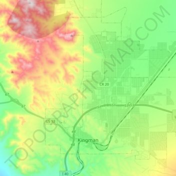
Nome: Mapa topográfico Kingman, altitude, relevo.
Local: Kingman, Mohave County, Arizona, United States (35.17405 -114.09481 35.28733 -113.92299)
Altitude média: 1.131 m
Altitude mínima: 827 m
Altitude máxima: 1.648 m
Faça uma doação
Outros mapas topográficos
Clique em um mapa para visualizar sua topografia, sua altitude e seu relevo.
Kingman
United States > Arizona > Mohave County > Kingman
Lt. Edward Fitzgerald Beale, a U.S. Navy officer in the service of the U.S. Army Corps of Topographical Engineers, was ordered by the U.S. War Department to build a federal wagon road across the 35th Parallel. His secondary orders were to test the feasibility of the use of camels as pack animals in the…
Altitude média: 1.131 m
Faça uma doação
Faça uma doação
Bullhead City
United States > Arizona > Mohave County > Bullhead City > Bullhead City
Altitude média: 245 m
Fort Mojave Indian Tribe
United States > Arizona > Mohave County > Mohave Valley
Altitude média: 362 m
Kingman
United States > Arizona > Mohave County > Kingman
Lt. Edward Fitzgerald Beale, a U.S. Navy officer in the service of the Army Corps of Topographical Engineers, was ordered by the U.S. War Department to build a federal wagon road across the 35th parallel. His secondary orders were to test the feasibility of the use of camels as pack animals in the Southwestern…
Altitude média: 1.116 m
Faça uma doação
Faça uma doação
Faça uma doação
Faça uma doação