
Mapa topográfico Dedham
Mapa interativo
Clique no mapa para exibir a altitude.
Sobre este mapa
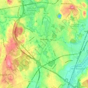
Nome: Mapa topográfico Dedham, altitude, relevo.
Local: Dedham, Norfolk County, Massachusetts, United States (42.20922 -71.23172 42.28046 -71.13075)
Altitude média: 43 m
Altitude mínima: -24 m
Altitude máxima: 100 m
The first man-made canal in North America, Mother Brook, was created in Dedham in 1639. It linked the Charles River to the Neponset River. Although both are slow-moving rivers, they are at different elevations. The difference in elevation made the canal's current swift enough to power several local mills.
Outros mapas topográficos
Clique em um mapa para visualizar sua topografia, sua altitude e seu relevo.
Ashcroft
United States > Massachusetts > Norfolk County > Dedham > Ashcroft
Ashcroft, Dedham, Norfolk County, Massachusetts, 02026-5036, United States
Altitude média: 30 m