
Obrigado por apoiar este site ❤️
Faça uma doação
Faça uma doação
Mapa topográfico Chengdu
Clique no mapa para exibir a altitude.
Obrigado por apoiar este site ❤️
Faça uma doação
Faça uma doação
Chengdu
The vast plain on which Chengdu is located has an elevation ranging from 450 to 720 metres (1,480 to 2,360 feet).
Obrigado por apoiar este site ❤️
Faça uma doação
Faça uma doação
Sobre este mapa
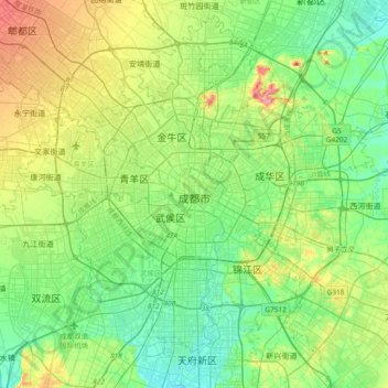
Nome: Mapa topográfico Chengdu, altitude, relevo.
Altitude média: 505 m
Altitude mínima: 469 m
Altitude máxima: 590 m
Obrigado por apoiar este site ❤️
Faça uma doação
Faça uma doação
Outros mapas topográficos
Clique em um mapa para visualizar sua topografia, sua altitude e seu relevo.
Wuhou District
The terrain of Wuhou District is flat, sloping from northwest to southeast, with an average altitude of 502.5 meters. The plains within the territory are composed of flood plains, alluvial fans, fan plains and other plains. The geological structure of the entire region is mainly Quaternary loose accumulations.
Altitude média: 492 m
Obrigado por apoiar este site ❤️
Faça uma doação
Faça uma doação