
Obrigado por apoiar este site ❤️
Faça uma doação
Faça uma doação
Mapa topográfico Brittany
Clique no mapa para exibir a altitude.
Obrigado por apoiar este site ❤️
Faça uma doação
Faça uma doação
Brittany
The Armorican massif reaches its maximal elevation outside of Brittany, in neighbouring Mayenne, at 417 m, and slopes towards the west before straightening on its western extremity, with the Montagnes Noires and the Monts d'Arrée. The highest hill in Brittany is the Roc'h Ruz in the Monts d'Arrée, at 385 m (1,263 ft). It is closely followed by several neighbouring hills culminating at around 384 m above sea level.
Obrigado por apoiar este site ❤️
Faça uma doação
Faça uma doação
Sobre este mapa
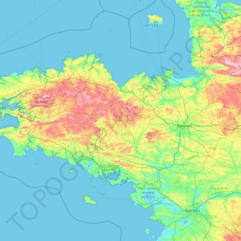
Nome: Mapa topográfico Brittany, altitude, relevo.
Altitude média: 50 m
Altitude mínima: -3 m
Altitude máxima: 371 m
Obrigado por apoiar este site ❤️
Faça uma doação
Faça uma doação