
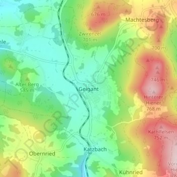
Mapa topográfico Geigant
Mapa interativo
Clique no mapa para exibir a altitude.
Sobre este mapa
Nome: Mapa topográfico Geigant, altitude, relevo.
Altitude média: 582 m
Altitude mínima: 468 m
Altitude máxima: 772 m
Outros mapas topográficos
Clique em um mapa para visualizar sua topografia, sua altitude e seu relevo.
Perlhütte
Deutschland > Bayern > Landkreis Cham > Waldmünchen
Perlhütte, Waldmünchen, Landkreis Cham, Bayern, 93449, Deutschland
Altitude média: 583 m
Spielberg
Deutschland > Bayern > Landkreis Cham > Waldmünchen
Spielberg, Waldmünchen, Landkreis Cham, Bayern, 93492, Deutschland
Altitude média: 578 m