
Obrigado por apoiar este site ❤️
Faça uma doação
Faça uma doação
Mapa topográfico Tofte
Clique no mapa para exibir a altitude.
Obrigado por apoiar este site ❤️
Faça uma doação
Faça uma doação
Sobre este mapa
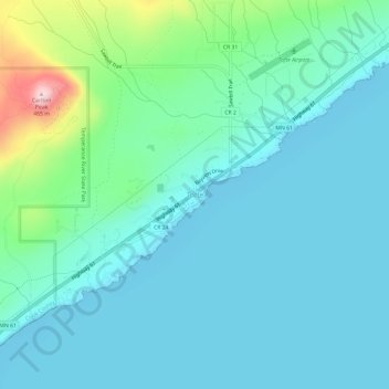
Nome: Mapa topográfico Tofte, altitude, relevo.
Altitude média: 223 m
Altitude mínima: 175 m
Altitude máxima: 448 m
Obrigado por apoiar este site ❤️
Faça uma doação
Faça uma doação
Outros mapas topográficos
Clique em um mapa para visualizar sua topografia, sua altitude e seu relevo.
Obrigado por apoiar este site ❤️
Faça uma doação
Faça uma doação
Grand Portage National Monument
United States > Minnesota > Cook County
The portage begins on Lake Superior, elevation 600 feet (180 m), rising as it moves westward through two notches in the Sawtooth Mountain range. It briefly levels off around 1,000 feet (300 m) after 2.6 miles (4.2 km). Another 1.5 miles (2.4 km) you reach the inland county highway. From here, the trail is more…
Altitude média: 314 m
Obrigado por apoiar este site ❤️
Faça uma doação
Faça uma doação