
Faça uma doação
Mapa topográfico Humacao
Clique no mapa para exibir a altitude.
Faça uma doação
Humacao
Humacao is located in the southeast coast of Puerto Rico. It is bordered by the municipalities of Naguabo to the north, Yabucoa to the south, and Las Piedras to the west. The Atlantic Ocean borders the city in the east. Humacao is located in the region of the Eastern Coastal Plains, with most of its territory being flat. There are minor elevations to the southwest, like Candelero Hill, and northwest, like Mabú. Humacao's territory covers 45 square miles (117 km2). Two islands belong to Humacao: Cayo Santiago and Cayo Batata.
Faça uma doação
Sobre este mapa
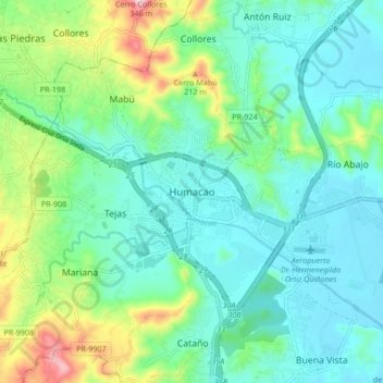
Nome: Mapa topográfico Humacao, altitude, relevo.
Local: Humacao, Puerto Rico, 00792, United States (18.10918 -65.86501 18.18918 -65.78501)
Altitude média: 78 m
Altitude mínima: 0 m
Altitude máxima: 312 m
Faça uma doação