
Obrigado por apoiar este site ❤️
Faça uma doação
Faça uma doação
Mapa topográfico LaFollette
Clique no mapa para exibir a altitude.
Obrigado por apoiar este site ❤️
Faça uma doação
Faça uma doação
LaFollette
According to the United States Census Bureau, the city has a total area of 4.9 sq mi (12.7 km2), all land. The elevation varies around the city, around 1,050 ft (320 m) in the valley areas to 1,500 ft (460 m) on ridge tops. The average elevation is around 1,150 ft (350 m).
Obrigado por apoiar este site ❤️
Faça uma doação
Faça uma doação
Sobre este mapa
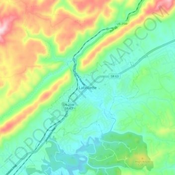
Nome: Mapa topográfico LaFollette, altitude, relevo.
Altitude média: 435 m
Altitude mínima: 301 m
Altitude máxima: 726 m
Obrigado por apoiar este site ❤️
Faça uma doação
Faça uma doação