
Obrigado por apoiar este site ❤️
Faça uma doação
Faça uma doação
Mapa topográfico Eibar
Clique no mapa para exibir a altitude.
Obrigado por apoiar este site ❤️
Faça uma doação
Faça uma doação
Eibar
Eibar lies at an altitude of 121m above sea level, in the west of the province of Gipuzkoa, very close to Biscay. Eibar has an oceanic climate. The town lies in a narrow valley in a mountainous area, with mountains like Karakate, Kalamua and Akondia being between 700 and 800 metres tall. Eibar is traversed by the river Ego, which is a tributary of the Deba.
Obrigado por apoiar este site ❤️
Faça uma doação
Faça uma doação
Sobre este mapa
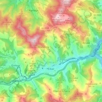
Nome: Mapa topográfico Eibar, altitude, relevo.
Altitude média: 367 m
Altitude mínima: 74 m
Altitude máxima: 768 m
Obrigado por apoiar este site ❤️
Faça uma doação
Faça uma doação
Outros mapas topográficos
Clique em um mapa para visualizar sua topografia, sua altitude e seu relevo.
Karakate
Spain > Autonomous Community of the Basque Country > Debabarrena > Soraluze
Altitude média: 366 m