
Mapa topográfico Alderley Edge
Clique no mapa para exibir a altitude.
Alderley Edge
Alderley Edge is 6 miles (10 km) northwest of Macclesfield and 12 miles (19 km) south of Manchester, at the base of a steep and thickly wooded sandstone escarpment, Alderley Edge, which is the area's chief topographical feature and overlooks the Cheshire Plain.
Sobre este mapa
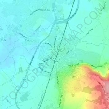
Nome: Mapa topográfico Alderley Edge, altitude, relevo.
Local: Alderley Edge, Cheshire East, England, United Kingdom (53.29448 -2.25853 53.31426 -2.20820)
Altitude média: 91 m
Altitude mínima: 63 m
Altitude máxima: 194 m
Outros mapas topográficos
Clique em um mapa para visualizar sua topografia, sua altitude e seu relevo.
Whirley Grove
United Kingdom > England > Cheshire East > Macclesfield > Whirley Grove
Altitude média: 154 m
Peckforton Moss
United Kingdom > England > Cheshire East > Bulkeley > Peckforton
Altitude média: 100 m
Shining Tor
United Kingdom > England > Cheshire East
Shining Tor is the highest hill in Cheshire, England. The summit has an elevation of 559 m (1,834 ft) above sea level. It is in the Peak District, between the towns of Macclesfield in Cheshire and Buxton in Derbyshire, and is on the administrative boundary between Derbyshire and Cheshire East. The hill is at…
Altitude média: 440 m
Higher Poynton
United Kingdom > England > Cheshire East > Poynton > Higher Poynton
Altitude média: 157 m