Geolocalizar

Mapa topográfico Wittersham

Mapa interativo

Clique no mapa para exibir a altitude.

Sobre este mapa

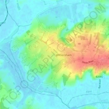
Nome: Mapa topográfico Wittersham, altitude, relevo.

Local: Wittersham, Ashford, Kent, South East England, England, United Kingdom (50.99358 0.66207 51.03807 0.73369)

Altitude média: 18 m

Altitude mínima: -3 m

Altitude máxima: 68 m

Outros mapas topográficos

Clique em um mapa para visualizar sua topografia, sua altitude e seu relevo.

Smeeth

United Kingdom > England > Kent > Ashford

Smeeth, Ashford, Kent, South East England, England, United Kingdom

Altitude média: 67 m

Shirkoak

United Kingdom > England > Kent > Ashford > Woodchurch > Shirkoak

Shirkoak, Woodchurch, Ashford, Kent, South East England, England, TN26 3QP, United Kingdom

Altitude média: 38 m

Repton

United Kingdom > England > Kent > Ashford

Repton, Repton Park, Orchard Heights, Ashford, Kent, South East England, England, United Kingdom

Altitude média: 55 m