
Mapa topográfico Mount Washington
Mapa interativo
Clique no mapa para exibir a altitude.
Sobre este mapa
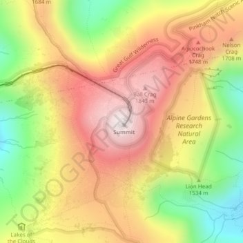
Nome: Mapa topográfico Mount Washington, altitude, relevo.
Local: Mount Washington, Coös County, New Hampshire, United States (44.27044 -71.30335 44.27054 -71.30325)
Altitude média: 1.568 m
Altitude mínima: 1.161 m
Altitude máxima: 1.911 m
Mount Washington, in New Hampshire, is the highest peak in the Northeastern United States at 6,288.2 ft (1,916.6 m) and the most topographically prominent mountain east of the Mississippi River.
Outros mapas topográficos
Clique em um mapa para visualizar sua topografia, sua altitude e seu relevo.
Kidderville
United States > New Hampshire > Coos County > Colebrook
Kidderville, Colebrook, Coös County, New Hampshire, United States
Altitude média: 472 m
Dixville
United States > New Hampshire > Coos County
Dixville, Coös County, New Hampshire, United States
Altitude média: 635 m
Northumberland
United States > New Hampshire > Coos County
Northumberland, Coös County, New Hampshire, United States
Altitude média: 383 m
Stark
United States > New Hampshire > Coos County
Stark, Coös County, New Hampshire, United States
Altitude média: 526 m
Shelburne
United States > New Hampshire > Coos County
Shelburne, Coös County, New Hampshire, United States
Altitude média: 467 m
Groveton
United States > New Hampshire > Coos County
Groveton, Northumberland, Coös County, New Hampshire, United States
Altitude média: 304 m
Columbia
United States > New Hampshire > Coos County
Columbia, Coös County, New Hampshire, United States
Altitude média: 553 m
Dummer
United States > New Hampshire > Coos County
Dummer, Coös County, New Hampshire, United States
Altitude média: 419 m
Twin Mountain
United States > New Hampshire > Coos County > Carroll
Twin Mountain, Carroll, Coös County, New Hampshire, 03595, United States
Altitude média: 490 m
Pinkham Notch
United States > New Hampshire > Coos County
Pinkham Notch, Pinkham's Grant, Coös County, New Hampshire, United States
Altitude média: 767 m
Milan
United States > New Hampshire > Coos County
Milan, Coös County, New Hampshire, 03588, United States
Altitude média: 448 m
Stratford
United States > New Hampshire > Coos County
Stratford, Coös County, New Hampshire, 03590, United States
Altitude média: 497 m
Castellated Ridge
United States > New Hampshire > Coos County
Castellated Ridge, Low and Burbank's Grant, Coös County, New Hampshire, United States
Altitude média: 1.080 m
Lost Nation
United States > New Hampshire > Coos County > Northumberland
Lost Nation, Northumberland, Coös County, New Hampshire, United States
Altitude média: 363 m
North Stratford
United States > New Hampshire > Coos County
North Stratford, Stratford, Coös County, New Hampshire, 03590, United States
Altitude média: 340 m
Colebrook
United States > New Hampshire > Coos County
Colebrook, Coös County, New Hampshire, 03576, United States
Altitude média: 476 m
Whitefield
United States > New Hampshire > Coos County
Whitefield, Coös County, New Hampshire, United States
Altitude média: 365 m
Gorham
United States > New Hampshire > Coos County
Gorham, Coös County, New Hampshire, 03581, United States
Altitude média: 477 m
Wildcat Mountain
United States > New Hampshire > Coos County
Wildcat Mountain, Coös County, New Hampshire, United States
Altitude média: 1.055 m
Upper Kidderville
United States > New Hampshire > Coos County > Colebrook
Upper Kidderville, Colebrook, Coos County, New Hampshire, United States
Altitude média: 478 m
Pittsburg
United States > New Hampshire > Coos County
Pittsburg, Coös County, New Hampshire, United States
Altitude média: 522 m
Castle Mountain
United States > New Hampshire > Coos County
Castle Mountain, Coos County, New Hampshire, United States
Altitude média: 937 m
Carroll
United States > New Hampshire > Coos County
Carroll, Coös County, New Hampshire, United States
Altitude média: 562 m
Lancaster
United States > New Hampshire > Coos County
Lancaster, Coös County, New Hampshire, 03584, United States
Altitude média: 371 m
Bretton Woods
United States > New Hampshire > Coos County > Carroll
Bretton Woods, Carroll, Coös County, New Hampshire, 03575, United States
Altitude média: 577 m
Clarksville
United States > New Hampshire > Coos County
Clarksville, Coös County, New Hampshire, United States
Altitude média: 570 m
Mount Crescent
United States > New Hampshire > Coos County
Mount Crescent, Coos County, New Hampshire, 03593, United States
Altitude média: 748 m
Triple Falls
United States > New Hampshire > Coos County > Gorham
Triple Falls, Gorham, Coos County, New Hampshire, 03593, United States
Altitude média: 558 m
Randolph
United States > New Hampshire > Coos County
Randolph, Coös County, New Hampshire, 03593, United States
Altitude média: 594 m
LIttle Diamond Pond
United States > New Hampshire > Coos County > Stewartstown
LIttle Diamond Pond, Stewartstown, Coos County, New Hampshire, United States
Altitude média: 693 m
Jefferson Highland
United States > New Hampshire > Coos County > Jefferson > Jefferson Highland
Jefferson Highland, Jefferson, Coos County, New Hampshire, 03583, United States
Altitude média: 451 m
Jefferson
United States > New Hampshire > Coos County
Jefferson, Coös County, New Hampshire, 03583, United States
Altitude média: 493 m
Dixville Notch
United States > New Hampshire > Coos County
Dixville Notch, Coos County, New Hampshire, United States
Altitude média: 655 m
Stewartstown
United States > New Hampshire > Coos County
Stewartstown, Coös County, New Hampshire, 03597, United States
Altitude média: 485 m
Dalton
United States > New Hampshire > Coos County
Dalton, Coös County, New Hampshire, United States
Altitude média: 375 m
Errol
United States > New Hampshire > Coos County
Errol, Coös County, New Hampshire, United States
Altitude média: 453 m
Mount Eisenhower
United States > New Hampshire > Coos County
Mount Eisenhower, Coos County, New Hampshire, 03589, United States
Altitude média: 1.142 m