
Obrigado por apoiar este site ❤️
Faça uma doação
Faça uma doação
Mapa topográfico Black Mountain
Clique no mapa para exibir a altitude.
Obrigado por apoiar este site ❤️
Faça uma doação
Faça uma doação
Sobre este mapa
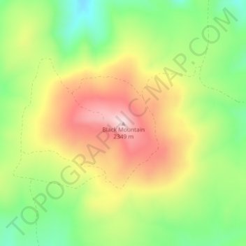
Nome: Mapa topográfico Black Mountain, altitude, relevo.
Local: Black Mountain, Rich County, Utah, United States (41.96044 -111.23136 41.96054 -111.23126)
Altitude média: 2.157 m
Altitude mínima: 1.998 m
Altitude máxima: 2.335 m
Obrigado por apoiar este site ❤️
Faça uma doação
Faça uma doação
Outros mapas topográficos
Clique em um mapa para visualizar sua topografia, sua altitude e seu relevo.
Bear Lake
United States > Utah > Rich County > Garden City
Formed in a half graben valley straddling the Idaho-Utah border, the lake has an approximate area of 109 square miles (280 km2) and sits at an elevation of 5,924 feet (1,806 m) along the northeast side of the Wasatch Range and the east side of the Bear River Mountains.
Altitude média: 2.038 m
Obrigado por apoiar este site ❤️
Faça uma doação
Faça uma doação