Geolocalizar

Mapa topográfico Yokuts Valley

Clique no mapa para exibir a altitude.

Yokuts Valley

Yokuts Valley (formerly, Squaw Valley) is a census-designated place located in Fresno County, California, in the United States. As of the 2010 census, the CDP had a total population of 3,162, up from 2,691 at the 2000 census. Yokuts Valley is located 9 miles (14 km) north-northeast of Orange Cove and 30 miles (48 km) east of Fresno, at an elevation of 1,631 ft (497 m).

Wikipedia (CC-BY-SA 3.0)

Sobre este mapa

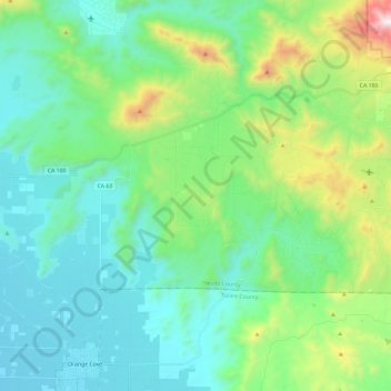
Nome: Mapa topográfico Yokuts Valley, altitude, relevo.

Local: Yokuts Valley, Fresno County, CAL Fire Southern Region, California, United States (36.65755 -119.30466 36.75426 -119.06844)

Altitude média: 437 m

Altitude mínima: 117 m

Altitude máxima: 1.557 m

Outros mapas topográficos

Clique em um mapa para visualizar sua topografia, sua altitude e seu relevo.

Fresno

United States > California > Fresno County

Altitude média: 98 m

Pinedale

United States > California > Fresno County > Fresno

Pinedale is a previously unincorporated community in Fresno County, California. It lies at an elevation of 348 feet (106 m). It was once a rural community located on the Southern Pacific Railroad 3.5 miles (5.6 km) north-northwest of Clovis but has since become surrounded and annexed by the city of Fresno.…

Altitude média: 107 m

Yokuts Valley

United States > California > Fresno County

As of the 2010 census, the CDP had a total population of 3,162, up from 2,691 at the 2000 census. Yokuts Valley is located 9 miles (14 km) north-northeast of Orange Cove and 30 miles (48 km) east of Fresno, at an elevation of 1,631 ft (497 m).

Altitude média: 551 m

Burrel

United States > California > Fresno County

Burrel (formerly, Burrell) is an unincorporated community in Fresno County, California. It is located 30 miles (48 km) southwest of Fresno, at an elevation of 203 feet (62 m).

Altitude média: 61 m

Westside

United States > California > Fresno County

Altitude média: 74 m

West Park

United States > California > Fresno County

Altitude média: 83 m

Monmouth

United States > California > Fresno County

Monmouth is a census-designated place in Fresno County, California. It is located 7.25 miles (12 km) west of Selma, at an elevation of 276 feet (84 m). At the 2010 census, Monmouth had a population of 152.

Altitude média: 84 m

Raisin City

United States > California > Fresno County

Raisin City (formerly, Raisin) is a census-designated place (CDP) in Fresno County, California, United States. The population was 380 at the 2010 census, up from 165 at the 2000 census. Raisin City is located 13 miles (21 km) south-southwest of downtown Fresno, at an elevation of 236 feet (72 m).

Altitude média: 73 m

Minkler

United States > California > Fresno County

Minkler is a census-designated place in eastern Fresno County, California. The place is located on Highway 180, 2.25 miles (3.6 km) east-southeast of Centerville and 7.6 miles north of Reedley at an elevation of 397 feet (121 m). It has a population of 1,003 people. The town is named for Charles O. Minkler, a…

Altitude média: 130 m

Malaga

United States > California > Fresno County

Malaga (Spanish: Málaga) is a census-designated place in Fresno County, California. It is located 6 miles (9.7 km) south-southeast of downtown Fresno, at an elevation of 295 feet (90 m). As of the 2010 census, Malaga had a population of 947.

Altitude média: 92 m

Laton

United States > California > Fresno County

Laton /ˈleɪtən/ is a census-designated place (CDP) in Fresno County, California, United States. The population was 1,824 at the 2010 census, up from 1,236 at the 2000 census. Laton is located 23 miles (37 km) south-southeast of Fresno, at an elevation of 259 feet (79 m).

Altitude média: 79 m

Caruthers

United States > California > Fresno County

Caruthers (/kəˈrʌðərz/) is a census-designated place (CDP) in Fresno County, California, United States. The population was 2,497 at the 2010 census, up from 2,103 at the 2000 census. Caruthers is located 15 miles (24 km) south of downtown Fresno, at an elevation of 246 feet (75 m).

Altitude média: 75 m

Easton

United States > California > Fresno County

Easton (formerly, Covel and Covell) is a census-designated place (CDP) in Fresno County, California, United States. The population was 2,083 at the 2010 census, up from 1,966 at the 2000 census. Easton is located 7.5 miles (12.1 km) south of downtown Fresno, at an elevation of 276 feet (84 m).

Altitude média: 85 m

Lanare

United States > California > Fresno County

Lanare is a community and census-designated place (CDP) in Fresno County, California, United States. The population was 589 at the 2010 census, up from 540 at the 2000 census. Lanare is located 24 miles (39 km) south-southwest of Fresno, at an elevation of 207 feet (63 m). The name is derived from Llewellyn A.…

Altitude média: 63 m

Cantua Creek

United States > California > Fresno County

Cantua Creek (formerly, Cantua and Cantuna) is a census-designated place (CDP) in Fresno County, California, United States. As of the 2010 census, the population was 466, down from the 655 reported at the 2000 census. Cantua Creek is located 11 miles (18 km) south-southwest of Tranquillity, at an elevation of…

Altitude média: 88 m

Biola

United States > California > Fresno County > Biola

Biola is a census-designated place (CDP) in Fresno County, California, United States. The population was 1,623 at the 2010 census, up from 1,037 in 2000. Biola is located 6 miles (9.7 km) north-northeast of Kerman, at an elevation of 253 feet (77 m).

Altitude média: 78 m

Bowles

United States > California > Fresno County

Bowles is a census-designated place (CDP) in Fresno County, California, United States. The population was 166 at the 2010 census, down from 182 at the 2000 census. Bowles is located 11 miles (18 km) south of downtown Fresno, at an elevation of 279 feet (85 m).

Altitude média: 86 m

Sunnyside

United States > California > Fresno County > Fresno

Altitude média: 101 m

Coalinga

United States > California > Fresno County

Coalinga is located 52 miles (84 km) southwest of Fresno, at an elevation of 673 feet (205 m). The topography is generally level, suitable for a number of field crops which do not require large amounts of water. It is located near the eastern foothills of the Diablo Range.

Altitude média: 188 m

Sunset Point

United States > California > Fresno County

Altitude média: 1.941 m

Squaw Valley

United States > California > Fresno County > Squaw Valley

Squaw Valley (formerly, Squawvalley) is a census-designated place located in Fresno County, California, in the United States. As of the 2010 census, the CDP had a total population of 3,162, up from 2,691 at the 2000 census. Despite the similar name, it is not the location of Squaw Valley Ski Resort or the 1960…

Altitude média: 557 m

Mono Creek

United States > California > Fresno County

Altitude média: 2.297 m

Del Rey

United States > California > Fresno County

Del Rey (Spanish for "of the King") is a census-designated place (CDP) in Fresno County, California, United States. The population was 1,639 at the 2010 census, up from 950 at the 2000 census. Del Rey is located 3.5 miles (5.6 km) south-southwest of Sanger, at an elevation of 344 (105 m).

Altitude média: 104 m

Prather

United States > California > Fresno County

Altitude média: 496 m

Miramonte

United States > California > Fresno County

Altitude média: 1.010 m

Wishon Dam

United States > California > Fresno County

Altitude média: 2.047 m

Shaver Lake

United States > California > Fresno County

Shaver Lake (formerly, Musick Creek and Musick Creek Heights) is a census-designated place (CDP) in Fresno County, California, United States. The population was 634 at the 2010 census, down from 705 at the 2000 census. Shaver Lake is on the southwest end of the lake of the same name, 10 miles (16 km) east of…

Altitude média: 1.563 m

Hume

United States > California > Fresno County

Altitude média: 1.730 m

Cedar Crest

United States > California > Fresno County

Altitude média: 2.241 m

Reedley

United States > California > Fresno County

Reedley is a city in Fresno County, California, United States. It is located in the San Joaquin Valley, 22 miles (35 km) east-southeast of Fresno, at an elevation of 348 feet (106 m). The population at the 2010 census was 24,194. Its chief economic source is agriculture, particularly fruit and vegetable…

Altitude média: 106 m

Crabtree

United States > California > Fresno County

Altitude média: 605 m

Friant

United States > California > Fresno County > Friant

Friant (formerly, Converse Ferry, Jones Ferry, Hamptonville, and Pollasky) is a census-designated place (CDP) in Fresno County, California, United States. The population was 549 at the 2010 census, down from 778 at the 2000 census. Friant is located 11.5 miles (19 km) north of Clovis, at an elevation of 344…

Altitude média: 135 m

Cedar Grove

United States > California > Fresno County

Altitude média: 1.761 m

Mount Morrow

United States > California > Fresno County

Altitude média: 3.393 m

Huron

United States > California > Fresno County

Huron is a small city in Fresno County, California, in the United States. As of the 2010 census, the population was 6,754, up from 6,306 at the 2000 census. During the harvest season, the population swells to over 15,000 people due to the influx of migrant farm workers. Huron is located 15 miles (24 km)…

Altitude média: 110 m

Helm

United States > California > Fresno County

Altitude média: 56 m

Coalinga

United States > California > Fresno County > Coalinga > Coalinga

Coalinga is located 52 miles (84 km) southwest of Fresno, at an elevation of 673 feet (205 m). The topography is generally level, suitable for a number of field crops which do not require large amounts of water. It is located near the eastern foothills of the Diablo Range.

Altitude média: 216 m