
Obrigado por apoiar este site ❤️
Faça uma doação
Faça uma doação
Mapa topográfico Channel Islands
Clique no mapa para exibir a altitude.
Obrigado por apoiar este site ❤️
Faça uma doação
Faça uma doação
Channel Islands
The Channel Islands at low elevations are virtually frost-free and constitute one of the few such areas in the 48 contiguous US states. It snows only rarely on higher mountain peaks.
Obrigado por apoiar este site ❤️
Faça uma doação
Faça uma doação
Sobre este mapa
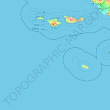
Nome: Mapa topográfico Channel Islands, altitude, relevo.
Altitude média: 4 m
Altitude mínima: 0 m
Altitude máxima: 689 m
Obrigado por apoiar este site ❤️
Faça uma doação
Faça uma doação
Outros mapas topográficos
Clique em um mapa para visualizar sua topografia, sua altitude e seu relevo.
Obrigado por apoiar este site ❤️
Faça uma doação
Faça uma doação
Obrigado por apoiar este site ❤️
Faça uma doação
Faça uma doação
Obrigado por apoiar este site ❤️
Faça uma doação
Faça uma doação
Jalama Beach County Park
United States > California > Santa Barbara County > Jalama
Altitude média: 40 m
Obrigado por apoiar este site ❤️
Faça uma doação
Faça uma doação
North Santa Maria
United States > California > Santa Barbara County > Santa Maria
Altitude média: 65 m
Obrigado por apoiar este site ❤️
Faça uma doação
Faça uma doação
Obrigado por apoiar este site ❤️
Faça uma doação
Faça uma doação
Las Positas Meadows
United States > California > Santa Barbara County > Santa Barbara
Altitude média: 66 m