
Mapa topográfico Waze
Mapa interativo
Clique no mapa para exibir a altitude.
Sobre este mapa
Nome: Mapa topográfico Waze, altitude, relevo.
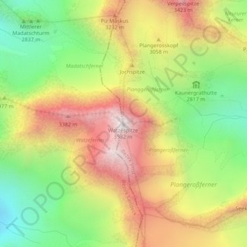
Local: Waze, St. Leonhard im Pitztal, Imst, Tirol, Österreich (46.98962 10.79537 46.98972 10.79547)
Altitude média: 2.932 m
Altitude mínima: 2.418 m
Altitude máxima: 3.490 m
Outros mapas topográficos
Clique em um mapa para visualizar sua topografia, sua altitude e seu relevo.
Rostizkogel
Österreich > Tirol > St. Leonhard im Pitztal
Rostizkogel, St. Leonhard im Pitztal, Imst, Tirol, Österreich
Altitude média: 2.936 m
Verpeilspitze
Österreich > Tirol > St. Leonhard im Pitztal
Verpeilspitze, St. Leonhard im Pitztal, Imst, Tirol, Österreich
Altitude média: 2.848 m
Mittelbergferner
Österreich > Tirol > St. Leonhard im Pitztal
Mittelbergferner, BIG3 Aussichtsplattform, St. Leonhard im Pitztal, Imst, Tirol, 6481, Österreich
Altitude média: 2.976 m
Taschachferner
Österreich > Tirol > St. Leonhard im Pitztal
Taschachferner, Pitztaler Gletschersteig, St. Leonhard im Pitztal, Imst, Tirol, 6481, Österreich
Altitude média: 3.208 m