
Mapa topográfico Gothic Mountain
Clique no mapa para exibir a altitude.
Sobre este mapa
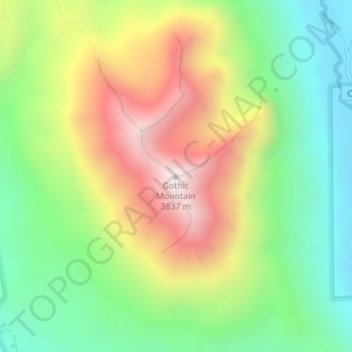
Nome: Mapa topográfico Gothic Mountain, altitude, relevo.
Local: Gothic Mountain, Gunnison County, Colorado, United States (38.95633 -107.01065 38.95643 -107.01055)
Altitude média: 3.297 m
Altitude mínima: 2.908 m
Altitude máxima: 3.835 m
Outros mapas topográficos
Clique em um mapa para visualizar sua topografia, sua altitude e seu relevo.
Crested Butte
United States > Colorado > Gunnison County
At the 2020 United States Census, the town had a total area of 535 acres (2.166 km2), all of it land. Crested Butte lies at an elevation of 8,885 feet (2,708 m) above sea level.
Altitude média: 2.798 m
Gunnison
United States > Colorado > Gunnison County
Also in 1880, the cattle industry in Gunnison was established. Realizing the poor conditions for farming (with only about eleven inches of rainfall annually and the short growing season due to the high elevation and alpine environment) the local farmers turned to ranching and began breeding cattle. To do this…
Altitude média: 2.369 m